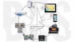
For those reading along, here is the sum total of the "cobbled together, jury-rigged, Rube Goldberg" system we had on our boat...
-At the 1900 position you have the Raymarine autopilot that came with the boat
-At the 2000 position you have the Raymarine ST60 instruments that came with the boat
-At the 2200 position you have the Furuno 1st Watch radar I was planning to add (we actually had an old JRC that I was going to replace)
-At the 2300 position you have the Brookhouse iMux.
-Then the iPad chartplotter
-Then the iPhone backup (of which we had 4)
-At the 1600 position you have the Standard Horizon GX 2200
-At the 1700 position you have other instrumentation that could be optionally added via the existing NMEA/SeaTalk wiring in the boat (and monitored via iNavX) like engine data, tankage, etc.
Here is what it took to make it all work as a unified system on a single iPad at the helm...
1. Run a SeaTalk cable from the Raymarine Tri-Data instrument at the nav station (or Tee-in anywhere in the cable) - to the iMux and follow the wiring instructions for the iMux. Turn on your instruments. You now have all NMEA/SeaTalk data being broadcast via onboard Wifi.
2. Pick up your iPad and select the iMux wifi signal you now see and enter the password given to you with the iMux. Now go into iNavX and set the TCP/IP settings for the iMux. You now have all NMEA/SeaTalk data coming through to your chartplotter where you can see everything (as tabs at the top of your chart, and/or via in the full instruments dashboard shown in the 1700 image below) from windspeed, wind direction, boat speed, depth, state of charge, water temp, air temp, you name it. Anything coming through that NMEA/SeaTalk wire is now on your chartplotter (AND all other i-devices on your boat). A couple more settings in iNavX and you also have an AP repeater on your iPad via the same NMEA/SeaTalk backbone.
3. Turn the instruments back off and run a couple of wires from your Standard Horizon GX2200 into the appropriate inputs on the iMux. Turn everything back on, including the VHF. You now have live AIS on your charts where you can monitor and touch targets and get all the typical AIS data in the pop-up you'd expect from any advanced MFD.
That's it. That's all you have to do to have a fully functional, fully capable MFD at the helm...and as many additional back-up i-devices you might have onboard (we had 2 iPads and 4 phones and ALL of them worked with this system).
The Furuno 1st Watch only requires power (no additional wiring). So it's very easy to add and could probably use the same power connection your current radar dome uses. Then you install the app on your i-Device, and now you also have full-featured hi-def radar on the chartplotter at the helm and all other i-devices on your boat.
It's really not that hard - unless one needs it be for some reason. More coming soon on video.